By Michael Pearsall, P.Eng., CVS, CVM, FICE, FEC
As promised last time, I am going to provide a brief case study of a recent successful Value Engineering workshop at the Ministry of Transportation (MTO) in Thunder Bay Ontario, Canada.
Over the years I have heard many nay-sayers state that with modern thorough Environmental Assessment (EA) processes there is little room left for any real improvement through a Value Engineering workshop as everything has been looked at. I would like to debunk that myth and share with you a summary of a very successful recent workshop I was fortunate to be able to see part of first hand. The next few paragraphs are abridged text from the study report which I have edited to fit this space.
An Environmental Study Report (ESR) was completed in 1997 for a 36-kilometre stretch of Highway 11/17 between Thunder Bay and Nipigon in northern Ontario following a full EA process. The recommended four-lane alignments where chosen primarily based on cost and impacts to property owners.
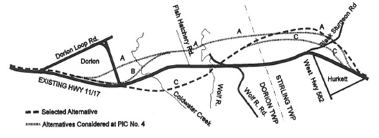
In a story, not unfamiliar with many projects of this nature, the preliminary design sat on a shelf for a few years before re-emerging as a priority for the agency and the original ESR required updating. Due to the significance of this project, a value engineering (VE) study was arranged to explore possibilities to maximize the functionality and value of a 13.4-kilometre segment of this corridor. The west limit of this VE study is roughly midway between the two Dorion loop intersections. The east study limit is roughly a few hundred metres east of the easterly Hurkett (Highway 582) intersections. The Annual Average Daily Traffic (AADT) volume in 2012 on this section of highway is approximately 3,800 vehicles per day, with 34% of vehicles being trucks. Notably the original alignment was selected because it “…requires less property and less land designated as Hamlet, and land-locks a smaller area of land.”
This Value Engineering (VE) Study was conducted for MTO by Stantec, Faithful+Gould and TBT Engineering. The overall objectives of the VE Study included:
- Developing VE Alternatives to obtain overall capital cost savings, life cycle cost savings and/or improved project performance while still achieving the functional requirements of the project (i.e., best value for the money spent)
- Combining VE Alternatives into overall project scenarios and evaluating those scenarios against the base case recommended plan to assist the design team in determining preferred alternatives to take forward
- Identifying project risks and how they can be mitigated
A five-day VE Workshop was held from October 17-21, 2016, in Thunder Bay, Ontario. The VE Study was led by Scot McClintock, CVS and followed the SAVE International job plan.
PROJECT ANALYSIS
Four VE tools were used by the VE Team to analyze the project. First, a FAST Diagram was developed by the VE Team that shows the basic function of the Highway 11/17 Base Case design as Create Four-Lane Divided Highway. The three required secondary functions are Create New 4-Lane Alignment, Twin Existing Highway and Access Highway. The function Access Highway is to be accomplished at this stage by the function Create At-grade Intersections. The required secondary functions Create New 4-Lane Alignment and Twin Existing Highway are both supported by secondary functions Carry Traffic, Separate Traffic, and Improve Intersecting Roads. The secondary functions Span Wolf River and Span Coldwater Creek are shown to only support the function Create New 4-Lane Alignment, reflecting the base case design. However, other alternatives that twin the highway in these locations would also need to span these waterways.
Second, the VE Team prepared a simple but very project specific risk management spreadsheet. The three risks classified as high were “Hydro towers are adversely impacted by highway alignment”, “TCPL (Trans-Canada Pipeline – natural gas) is adversely impacted by highway alignment” and “Pre-loading requirements due to unknown subsoil conditions, primarily soft clays”. Although some ideas for mitigation of these risks are included on the risk spreadsheet, others were pursued during the VE workshop.
Third, the overall VE Team developed project specific Performance Criteria and Measures based on project information and much discussion. The Performance Measures were refined several times during the workshop. (Thank you once again to CalTrans for sharing this concept with us 15 years ago, it has proven a beneficial tool!)
Fourth, the Team weighted the Performance Criteria by consensus using two different methods. These criteria and their weights were used formally through a Graphical Pairwise Comparison method, with results numerically tabulated via Make It Rational™ software, following the Scenario Development Phase. Based on the above project analysis, four value target areas were selected for VE Team consideration.
VE ALTERNATIVES
The VE Team initially generated 66 ideas on the four value target areas. After an initial evaluation process the VE Team developed 16 VE Alternatives and identified 17 Design Suggestions for consideration of the project and design teams going forward.
The most significant VE Alternatives are described below:
- Twin entire alignment on most beneficial side for each segment (A-01). This alternative twins the entire alignment on the most beneficial side of the existing highway for each segment, minimizing design, construction, environmental impacts and impacts on existing traffic while offering an estimated capital cost savings of $94M. However, this alternative increases property buyouts and safety concerns from less than ideal curve radii and up to 40 intersections on mainline and curves. A-01 is the basis for Scenario D.
- Twin on north side of existing Highway 11/17 to Bible Camp Road then new alignment north connecting to base case (A-07). This alternative twins existing Highway 11/17 to the north to Bible Camp Road and then provides a new alignment north of the existing highway to cross the Wolf River and Coldwater Creek at more favourable locations, reduce construction over very soft clay deposits, increase reuse of existing alignment, and avoid several utility conflicts. A-07 offers estimated capital cost savings of $55.7M and is a key component of Scenario E.
- New alignment north of utility corridors then connecting at east study limits (A-13). This alternative suggests a new tangent alignment with few curves north of the utility corridors throughout the study limits, offering shortest travel distance, flat terrain, a lack of utility conflicts, and advantageous crossings at Coldwater Creek and Wolf River. In spite of a need for pre-loading, A-13 should expedite highway construction for a significant estimated capital cost saving is $63.6M. A-13 is the basis for Scenario D.
- New alignment south of electrical utility (HONI) corridor (A-17). This alternative keeps the new alignment south of the HONI corridor to eliminate conflicts with the corridor; minimize property fragmentation and impacts on natural habitat; simplify construction with flatter terrain and lower embankments; and improve safety with larger radius curves. A-17 offers a capital cost saving estimated at $5.2M and is a key component of Scenarios E and F.
- New lanes north of existing highway from west limit to Wolf River (A-22). This alternative suggests a new alignment north of the existing highway from the west limit to the Wolf River, offering a better Wolf River crossing, improved horizontal alignment, less utility (HONI) and property impacts, better soil conditions, shorter structures, and an advantageous location to access Fish Hatchery Road. With a very significant estimated capital saving of $41.4M, A-22 is a key component of Scenario F.
- New alignment further north from west end to station 21+800 (A-23). This alternative recommends a new alignment further north from the west limit to station 21+800 to minimize property impacts, simplify the Dorion Loop Road East intersection, provide more suitable Coldwater Creek and Wolf River crossings, and reduce construction in poor soil conditions. An option to VE Alternative A-22 above, A-23 offers an even more significant estimated capital saving of $50.6M and is also a key component of Scenario F.
- Eliminate new twin structures over existing highway and the existing Wolf River Bridge (C-13). This alternative eliminates the new twin structures over the existing highway from the base case and removes the existing Wolf River Bridge for an estimated capital cost saving of$14.4M while greatly simplifying construction, lowering fills, and eliminating future maintenance of three structures. A portion of existing Highway 11/17 will be closed via cul-de-sacs. C-13 is a key component of Scenario B.
- Provide T-intersection at Stewart Lake Road on the south (C-19). This alternative suggests a T-intersection at Stewart Lake Road on the south to provide additional access to properties in the east study area and reduce out of the way travel for Stewart Lake Road residents for a modest additional capital cost estimated at $0.2 M. Alternative C-19 is a key component of Scenario B.
VE SCENARIOS
The VE Team determined which VE Alternatives best fit together into VE Scenarios that make sense and can be presented as cohesive, complete design solutions. A total of six scenarios were developed, including the base case recommended four-lane alignment from the 1997 Environmental Study Report (ESR). The VE Team was careful to remove cost savings overlaps between the alternatives composing each of the scenarios.
DESCRIPTION OF VE SCENARIOS
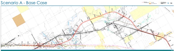
Scenario A – Base Case
The Base Case is the recommended four-lane alignment for Highway 11/17 between Highway 582 and Dorion Loop Road East from the 1997 Environmental Study Report (ESR). The estimated capital cost is based on 2016 dollars.
Estimated Capital Cost: $206.2 M
Scenario B: Base Case Modified
Scenario B is the base case with two modifications. First, eliminating new twin structures over the existing highway and removing the existing Wolf River Bridge to improve constructability in the Wolf River area. Second, improving performance by adding a T-intersection at Stewart Lake Road on the south.
Included VE Alternatives: C-13 and C-19
Estimated Capital Cost: $193.9 M
Estimated Capital Savings: $12.3 M
Scenario C: New Alignment North of Southern Utility Corridor
Scenario C is a new 4-lane alignment on the north side of the existing southern HEPC (electrical distribution) and natural gas (TCPL) utility corridor from the west study limit to the east study limit. This scenario offers a tangent alignment with few curves, the shortest travel distance, flat terrain for much of it, a lack of utility conflicts, and advantageous crossings at Coldwater Creek and Wolf River.
Included VE Alternatives: A-13
Estimated Capital Cost: $142.5 M
Estimated Capital Savings: $63.6 M
Scenario D: Twin entire alignment on most beneficial side for each segment
Scenario D twins the entire alignment on the most beneficial side of the existing highway for each segment, minimizing design, construction, environmental impacts, and impact on existing traffic. While offering the lowest capital cost, this scenario has the most property buyouts and safety concerns from less than ideal curve radii and up to 40 intersections on mainline and curves.
Included VE Alternatives: A-01
Estimated Capital Cost: $112.2 M
Estimated Capital Savings: $94.0 M
Scenario E: Twin on north side to Bible Camp Road; new alignment along south side of HONI corridor; connecting to base case twinning just beyond Stewart Lake Road
Scenario E twins on the north to Bible Camp Road; continues with a new alignment south of the HONI corridor; and connects to base case twinning just beyond Stewart Lake Road. This alignment crosses the Wolf River and Coldwater Creek at more favourable locations, reduces construction over very soft clay deposits and overall highway length, and avoids significant utility (HEPC, TCPL, rail and HONI) impacts.
Included VE Alternatives: A-07 and A-17
Estimated Capital Cost: $145.9 M
Estimated Capital Savings: $60.2 M
Scenario F: New alignment further north on west end; new alignment along south side of HONI corridor; connecting to base case twinning just beyond Stewart Lake Road
Scenario F is a new 4-lane alignment further north on the west end, continuing south of HONI corridor; and connecting to base case twinning just beyond Stewart Lake Road. This scenario simplifies the Dorion Loop Road East intersection, crosses Coldwater Creek and Wolf River at more favourable locations, reduces construction in poor soil conditions, reduces construction over very soft clay deposits and overall highway length, and avoids significant utility (HEPC, TCPL, rail and HONI) impacts.
Included VE Alternatives: A-17, A-22 and A-23
Estimated Capital Cost: $142.6 M
Estimated Capital Savings: $63.6 M
CONCLUSIONS
The six VE Scenarios were evaluated against each other using the weighted performance criteria and their respective units of measurement, as developed at the outset and refined during the VE study.
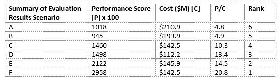
The conclusion that can be reached from the above analysis is that Scenario F is clearly the best solution, offering the best “value” based on the best performance and a significant cost savings. Scenario F can be considered the best value solution, providing excellent performance with regard to the community, the agency (MTO), and the Province at a more reasonable cost.
This has led to an identified savings of over $63M or a more than 30% reduction in capital cost! Congratulations to the project team for such great results and many thanks to them as well for letting me join them for part of the study so I could see these results being developed first hand. Not only does this study demonstrate that there is plenty of opportunity to improve upon EA approved projects with VE, but also how good function analysis can help. One of the identified functions was “Protect Utilities” and ultimately a large portion of the cost avoidance was in reducing utility impacts on a gas pipeline and two major electrical transmission corridors.
Until the next issue I would like to continue to encourage any transportation professional out there who would like to share their stories to contact me. Similarly, if you would like to learn more about this specific project please contact me as well and I will put you in touch with a member of the project team. I can be reached at mike.pearsall@ontario.ca.
Next issue – another interesting case study.